
Ground Penetrating Radar (GPR) Services in Vancouver
Trusted Experts in Utility Locating & Subsurface Surveys Since 2001
Why Choose Professional GPR Services?
Vancouver’s urban infrastructure is dense, complex, and ever-evolving. Whether you’re planning excavation, civil construction, or historical site development, understanding what’s underground is critical.
At Terraprobe, we offer non-invasive, high-precision Ground Penetrating Radar (GPR) services to detect and map subsurface utilities, voids, and structures—reducing risk and saving time.
Terraprobe Geoscience Corp. is a leading provider of professional Ground Penetrating Radar (GPR) services in Vancouver, specializing in utility locating, subsurface imaging, and geophysical surveys for construction, engineering, and infrastructure development.
With over 10,000 GPR investigations completed across Western Canada, our team delivers precise, non-destructive subsurface data to ensure safe and efficient project planning.
Whether you’re a civil engineer, municipal planner, construction manager, or environmental consultant, you can rely on Terraprobe for high-resolution GPR data, CAD-integrated mapping, and on-site field markings that keep your projects safe, compliant, and on schedule.
What Is GPR and Why Is It Used?
Ground Penetrating Radar is a geophysical technique that uses high-frequency electromagnetic waves to detect changes in subsurface materials. GPR identifies anomalies caused by differences in material density or composition—ideal for locating:
Metallic and non-metallic pipes
Locating both metallic and non-metallic pipes is critical for safe excavation and utility mapping. Unlike electromagnetic locators, which struggle with non-conductive materials, Terraprobe’s GPR technology detects a wide range of pipe types—including PVC, concrete, and clay. Our surveys provide accurate depth and position data, helping engineers and contractors avoid damage, reduce delays, and ensure regulatory compliance on complex job sites.
Abandoned utility lines
Abandoned or untraceable utilities pose serious hazards during excavation. Terraprobe’s GPR technology detects these undocumented lines—often missed by traditional locators due to broken tracer wires or outdated maps. Our real-time subsurface imaging enables accurate marking and safer, more compliant construction in Vancouver.
Voids, sinkholes, or erosion beneath pavement
Subsurface voids and erosion can lead to pavement collapse and costly repairs. Terraprobe uses high-resolution GPR to detect hidden gaps, sinkholes, or settlement beneath slabs and roadways—allowing for early intervention and informed maintenance decisions.
Reinforced concrete structures
Cutting or coring into concrete without knowing what’s inside is a major risk. Terraprobe’s GPR surveys accurately map rebar, post-tension cables, and conduits within slabs—ensuring safe, precise work on commercial and industrial sites across Vancouver.
Historical artifacts or unmarked burials
Terraprobe supports archaeologists and heritage professionals with non-invasive GPR surveys that locate unmarked graves, artifacts, and cultural features. Our precise imaging aids preservation efforts and regulatory compliance while minimizing ground disturbance.
In Vancouver’s dense urban environment and coastal soils, GPR offers a non-destructive way to gain clarity underground, especially where blueprints are outdated or incomplete.
Subsurface Utility Locating in Vancouver
Subsurface Utility Engineering (SUE) is critical to avoid costly utility strikes and delays during construction. Terraprobe offers GPR-based utility locating services that identify:
✅Water & sewer lines
✅Gas and oil pipelines
✅Communication & power conduits
✅Abandoned or unknown infrastructure
We operate under ASCE 38-02 SUE standards and provide data at Quality Level B, with options for QL-A hydro-vac confirmation when required. Deliverables include GPS-referenced utility maps integrated into AutoCAD or GIS files, complete with depth-to-top-of-target annotations.
Our GPR Services in Vancouver
✅ Utility Locating & Mapping
We help prevent costly utility strikes by accurately locating underground infrastructure prior to excavation or construction. Using a combination of dual-frequency GPR and electromagnetic (EM) locators, we provide Quality Level B utility data per ASCE 38-02 Subsurface Utility Engineering (SUE) standards, with optional QL-A confirmation through soft excavation (hydro-vac).
Deliverables include:
RTK-GPS-tagged utility locations
Depth-to-top-of-target annotations
Spray paint/flag markings
CAD/GIS-integrated maps
Our past work includes hundreds of utility locating projects in Metro Vancouver, including high-traffic corridors, construction zones, commercial lots, and industrial facilities.
Recent Projects:
- Broadway Subway borehole clearance
- Delta & Surrey utility relocation
- Brentwood Mall redevelopment
Beyond Utilities: Full Subsurface Imaging
From archaeological studies to structural void detection, Terraprobe’s GPR technology provides high-resolution, non-destructive imaging for:
Historical site investigations (e.g. Fort Rodd Hill & Fisgard Lighthouse)
Cemetery & burial site mapping
Structural condition assessments
Geotechnical and environmental studies
Historical site investigations (e.g. Fort Rodd Hill & Fisgard Lighthouse)
When it comes to Ground Penetrating Radar (GPR) services for archaeological and historical site investigations in Vancouver, Terraprobe is the trusted partner for contractors, engineers, and heritage consultants seeking reliable, high-resolution subsurface imaging. Our team combines over 50 years of technical expertise with state-of-the-art GPR technology to deliver non-invasive, accurate results that help protect and document valuable heritage assets3.
Contractors choose Terraprobe for historical site GPR surveys because we understand the unique requirements of working on sensitive and protected locations. Our approach is designed to minimize disturbance while maximizing data quality, supporting your project’s compliance, safety, and preservation goals. We know that buyers seeking archaeological GPR surveys, heritage site scanning, or historical site ground penetrating radar services demand both technical excellence and proven experience.
Key reasons to trust Terraprobe for your historical site GPR needs:
Specialized Experience: Our technicians have extensive experience with archaeological and indigenous site surveys, including mapping unmarked burial sites and detecting subsurface artifacts and features.
Advanced Equipment: We utilize a wide range of GPR antennas and the latest radar systems, allowing us to tailor our methodology for optimal depth and resolution based on site conditions.
Comprehensive Reporting: Our deliverables include detailed, easy-to-understand reports and 3D imaging, supporting heritage assessments, construction planning, and regulatory requirements.
Multi-Method Capabilities: In addition to GPR, we can integrate electromagnetic, aerial, and other geophysical methods for a complete picture of subsurface conditions.
Rapid Deployment & Local Expertise: With a large equipment pool and highly trained local technicians, we respond quickly to project needs across Vancouver and Western Canada.
Whether you are planning a redevelopment, conducting a heritage impact assessment, or need to locate and map historical features before construction, Terraprobe’s GPR services provide the accuracy, reliability, and documentation you need to move forward with confidence. Contact us today to discuss your project and see why we’re Vancouver’s leading provider of ground penetrating radar for historical and archaeological sites
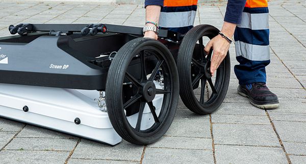
Using multi-channel systems like the IDS Stream-C and Stream-DP, we achieve up to 100% area coverage with dual-polarized antennas—perfect for complex sites and urban settings.
Our Process: From Field to Final Report
Every GPR project follows a structured methodology to ensure data accuracy and usability:
-
Site Review & Preparation – We assess surface conditions, soil type, and scope to select the optimal radar system.
-
Data Collection – Performed by experienced crews using the appropriate GPR array and EM locators. GPR is either pushed manually or towed behind a vehicle or ATV depending on the site.
-
GPS Integration – All data is collected with RTK-level GPS positioning for precise georeferencing.
-
Processing & Analysis – Using IQMaps, Geolitix, or GRED HD, we generate detailed radargrams and export data to CAD/GIS formats.
-
Reporting & Deliverables – We provide marked-up site plans, depth estimates, anomaly maps, and technical reports tailored to client needs.
What Sets Terraprobe Apart?
- ✅ Established Expertise – Since 2001, our team has tackled projects from the Arctic to the Amazon, offering deep experience in diverse soil conditions, including clay, urban fill, and water-saturated environments.
- ✅ Advanced Equipment – We operate an extensive inventory of mid-to-high frequency radar systems (250 MHz – 2600 MHz) from industry leaders such as IDS, GSSI, and Sensors & Software.
✅ Professional Technicians – Our crews are led by certified Subsurface Utility Engineering (SUE) specialists and geophysicists with over 45 years of combined experience.
✅ Full-Service Delivery – From RTK-GPS data collection to 3D CAD rendering, our team delivers precise, actionable subsurface maps and reports you can rely on.
Led by certified SUE experts and geophysicists, our crews combine technical accuracy with on-site problem-solving and professionalism.
Who We Serve
Civil Engineers & Surveyors
Utility & Infrastructure Contractors
Environmental Consultants
Developers & Real Estate Planners
Archaeologists & Cultural Heritage Teams
Municipal and Provincial Governments
Let’s Talk About Your Project
Whether you’re planning a utility relocation, development survey, or archaeological assessment, we’re here to help.
📍 Serving Metro Vancouver & Western Canada
📞 604-553-4778 | 📧 gpr@terraprobe.com