
BLOG
Welcome to the Terraprobe Blog, your go-to resource for expert insights and updates on utility locating in Vancouver and concrete scanning in Vancouver. As a trusted provider of ground penetrating radar (GPR) services, we specialize in delivering accurate, efficient solutions to ensure safety and precision in every project. Whether you're planning construction, renovations, or archaeological surveys, our blog is here to guide you with professional tips, industry news, and success stories. Explore our articles to learn how Terraprobe can help you locate utilities, scan concrete, and uncover what's below the surface with confidence.
Understanding Ground Penetrating Radar (GPR) Prices and What Affects Them
In the realm of geotechnical exploration, Ground Penetrating Radar (GPR) stands out as a cutting-edge tool, capable of uncovering the unseen beneath our feet. But how much does it truly cost, and what factors dictate these prices? Understanding GPR prices isn't just about numbers—it's about unlocking the potential of this technology for your projects. From infrastructure assessments to archaeological digs, the value of GPR can vary significantly based on several key elements, including equipment sophistication, scanning depth, and field conditions. In this article, we'll demystify GPR pricing, offering insights into what drives costs and how to make informed decisions for your next venture. Whether you're a contractor, a researcher, or simply curious about this powerful technology, grasping the nuances of GPR pricing is essential. Join us as we delve into the essential aspects that influence these prices and learn how to navigate the layers of this fascinating technology!
Overview of GPR Technology and Its Applications
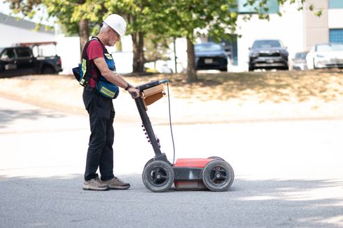
Ground Penetrating Radar (GPR) is an advanced geophysical method that utilizes radar pulses to image the subsurface. This non-destructive technique is highly effective in detecting and mapping subsurface objects, changes in material properties, and voids. GPR is widely used across various industries due to its versatility and precision. From infrastructure inspections to forensic investigations, GPR has become a crucial tool for professionals who need to see what lies beneath the surface without disturbing it.
moreCASE STUDY // XAXLIP FIRST NATIONS LAND SURVEY
Posted by Kelly Warkentin
CLIENT OBJECTIVE//
Terraprobe was approached by a client who is planning to develop some land belonging to the Xaxlip First Nation. As there is very little historical knowledge about potential burial sites on the land, the client needed to determine whether there was any indication of potential burial sites for further archaeological investigation. Terraprobe used GPR to scan the intended development for anomalies consistent with burial sites.
PROJECT APPLICATION//
To address this complex challenge, Terraprobe used a Leica Stream-DP multi-antenna
array GPR system towed behind a vehicle to collect GPR data on the site, providing near
100% coverage of the 5 acre area. Due to the large size of the land, a manually operated GPR system would take too much time to complete the survey with accuracy.
The client needed to determine if there were any ancient burial sites in the survey area. Development could not take place without the client completing this due diligence. If the GPR survey is not done and excavations uncover a burial location, all work would stop until an investigation is completed. This unplanned stoppage is expensive and much less desirable than a planned location and remediation of burial sites. Having GPR data that either
moreCASE STUDY // Accurate Utility Locating Critical to Crane Placement
Kelly Warkentin
CLIENT OBJECTIVE//
Terraprobe was approached by a client needing to conduct a sub-surface survey in an area roughly 1,000m sq. on grass and an asphalt parking lot in order to find a safe location to place a construction crane.
The client was aware that a large underground oil separator as well as water and storm utilities were located underground and needed to avoid placing the construction crane on top of these utilities in order to avoid damaging them.
PROJECT APPLICATION//
Terraprobe used the IDS Stream-DP array system, renowned for its efficiency and accuracy in subsurface imaging. Due to the system's capability to collect comprehensive data in a single pass, we were able to collect data quickly without the need for a grid pattern. This approach was both time-effective and required fewer resources, involving just one technician for the data collection phase.
The benefits of using the IDS Stream-DP system were manifold. Its ability to provide nearly 100% coverage ensured that even smaller, less obvious targets could be detected, a significant advantage over other GPR systems which might require more passes or more complex setups. This feature, coupled with the system's efficiency, offered the client a swift and economical solution, delivering valuable data that could be immediately used to assess and address the structural concerns of the causeway.
moreCASE STUDY// Causeway Void Detection
Posted by: Kelly Warkentin
CLIENT OBJECTIVE//
Terraprobe was approached by a client facing significant concerns about potential voids underneath a causeway, caused by water incursion. These voids posed a serious risk to the structural integrity of the causeway, prompting the need for a precise and reliable detection method. The client's primary objective was not only to identify the presence of these voids but also to understand their specific locations and the depth at which they occurred. This information was crucial for planning necessary remediation steps to ensure the longevity and safety of the infrastructure.
PROJECT APPLICATION//
To address this complex challenge, Terraprobe employed the cutting-edge IDS Stream-DP array system, renowned for its efficiency and accuracy in subsurface imaging. The system's capability to collect comprehensive data in a single pass without the need for a grid pattern significantly streamlined the process. This approach was both time-effective and required fewer resources, involving just one technician for the data collection phase.
Once the data was collected, it was meticulously processed using advanced software tools, Geolitix and IQMaps. These applications facilitated the creation of detailed 3D and 2D maps of the anomalies. The high-resolution imagery provided by these maps allowed for an accurate assessment of the anomalies' characteristics, enhancing the decision-making process for the client.
more